- Research tips and McCook Brick Company- solid as a brick (12/16/24)
- Big Give appreciation and some railroad characters (11/15/24)
- George Randel becomes a landowner, gets married, and takes in a Buffalo Bill show (9/20/24)
- The memoirs of George F. Randel, early settler of Red Willow County (9/12/24)
- Vietnam War Memorial honors Nebraskans who served (6/13/24)
- McCook business promotions - just prior to 1893 stock market crash (5/30/24)
- Shall we dance? Meet you at the Gayway (12/8/23)
Figuring out where the Methodist Church was built
Friday, February 5, 2021

Courtesy photo
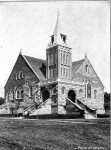
This photo of the original Methodist Church in McCook, on West First Street, was printed in the 1902 McCook High School annual.
It doesn’t hurt anyone to eat a little crow once in a while and it is apparently my turn to savor the dish. This column is going to center around McCook in the year 1909 which thankfully, is very well documented, through a Sanborn Map and the McCook High School 1909 class annual. Both of these are available for you to research on our website, www.swngs.org. The website is free for anyone to use!
So, here’s my crow story. I always thought the Methodist Church # 1 and the Methodist Church #2 were built on the same lot where todays church stands. I thought that #1 was torn down to build #2 and I was standing by that story based on my research of the Sanborn Maps and the picture of the 1909 Methodist Church in the annual. Wrong! The original ME Church was built on the NW Corner of West 1st and E streets. Three other churches existed on that block, all on the East side: Christian Church was situated facing south on the lot where the Gazette is today, 1st Baptist Church sat mid-block and actually still stands today but is associated with St. Albans Episcopal whose original building sat on the same lot as todays church but was built close to the alleyway and facing North from what I can see.
Perhaps I will be allowed to salt that crow before consuming if I explain how I had arrived at my erroneous conclusion! The 1909 Annual shows a picture of the old ME Church and the 1909 Sanborn Map of Main Street (Norris Ave.) shows the ME Church sitting where it is today! Problem is, had I looked at the 1909 Map of West 1st, there was also a ME Church! Of course, the annual would have been completed before May of 1909 and the map, completed later, show the old church and the location of the new church.
Sanborn Maps were for Fire Insurance purposes. Interestingly enough, the old ME Church was heated with hot air and had electric lights, while St. Albans was heated with stoves and the lighting was both gas and electric. The height of each church was mentioned with the tallest being the Baptist church measuring 18’ to the eaves.
To finish the ME story, the old church was still standing in 1921 and shows as being the home of the 7th Day Adventists in that year. It will take some more research to figure out when it was demolished, and apartment buildings built in its place.
Weather is going to be a big influence on the library being open due to the fact that Chris must drive from Curtis/Maywood to be there so please check Facebook for any announcements. This Saturday is our monthly meeting which is open to the public: 322 Norris Ave, RM 2-7 in the Temple Building at 1PM. There is an elevator for your use as we are on the second floor.

